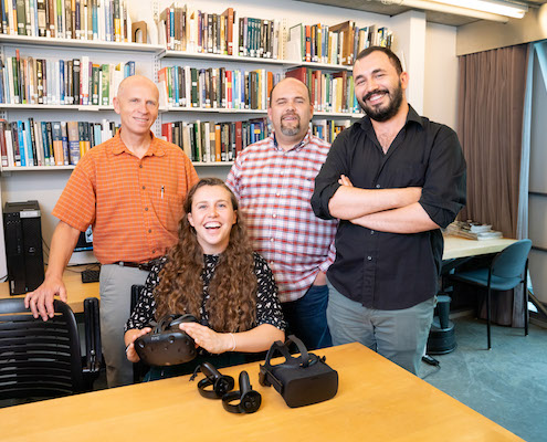
From left: Daniel Sheehan, Madeline Wrable, Ricardo Alvarez, Cagri Hakan Zaman. Photo: Bryce Vickmark
Virtual and augmented reality (VR/AR) were once the stuff of science fiction, yet users of the new GIS and Data Lab in Rotch Library are finding very real opportunities to deploy these immersive technologies.
“There is a big ‘aha’ moment when you use VR and AR,” says Ricardo Alvarez, a PhD candidate in the Department of Urban Studies and Planning whose research interests include the use of VR/AR for urban and spatial design. “It tricks your biology into thinking you are somewhere else, or someone else.”
Both Alvarez and Cagri Hakan Zaman, a PhD candidate in architecture, have provided invaluable input on planning VR/AR resources for the new GIS and Data Lab. They have worked closely with GIS Specialist Madeline Wrable, who has led the Libraries’ work in VR/AR, as well as Senior GIS Specialist Daniel Sheehan on selecting equipment, advising on the design of the space, and imagining potential applications for research. At MIT, those applications include everything from identifying regions of the brain that link memories, to training drones to avoid crashes, to visualizing sea level rise in Southern Florida. VR/AR makes sense as the next step in the evolution of tools to understand, analyze, and communicate spatially located information — it’s a new medium that actually puts you inside it.
“There is a fundamental aspect about seeing things in space; we learn better in space,” says Zaman, who develops AI systems that are trained by recording data of people experiencing virtual environments. “It’s not just giving you access to content, it’s giving you an experience. It has great potential to become the next library tool.”
Wrable thinks so, too. “I envision libraries becoming thought of as places to learn new technologies,” she says. “The GIS Lab is a natural home for spatial visualization software such as VR and AR.” With funding from the Libraries for experimental projects, she purchased the lab’s first VR equipment in 2017 and later piloted workshops for the MIT community. Alvarez was an enthusiastic participant, and Wrable has invited him to co-teach subsequent workshops with her.
As plans developed for the new, expanded GIS and Data Lab in Rotch, the Libraries and the School of Architecture and Planning (SA+P) began exploring how their interests in VR/AR could align. In addition to consulting with the Libraries on the Rotch lab, Zaman is leading efforts to set up another VR/AR space within SA+P. The school’s assistant dean, Ken Goldsmith, sees both spaces working together as part of “a continuum of resources.”
With the GIS and Data Lab open to anyone at MIT, it’s an ideal place for the community to explore the technology from a variety of disciplinary perspectives. It can also be the first step in what the team envisions as a learning pipeline for VR/AR. “I’m excited that MIT is investing in this and excited about MIT students being active participants,” says Alvarez. “I’m curious to see what the community will do with this technology.”
Whatever the future holds for VR/AR at MIT, the Libraries and SA+P have found in each other a refreshingly receptive and collaborative partner. “I don’t know where it’s going to go, but I know it’s a resource we need to have,” says Goldsmith. “We’ll be going down this road together.”


